Fetch data from Protected Planet. Specifically, data are downloaded from the World Database on Protected Areas (WDPA) and the World Database on Other Effective Area-Based Conservation Measures (WDOECM). Note that data are downloaded assuming non-commercial use.
Usage
wdpa_fetch(
  x,
  wait = FALSE,
  download_dir = tempdir(),
  force_download = FALSE,
  check_version = TRUE,
  n = NULL,
  page_wait = 2,
  datatype = "gdb",
  verbose = interactive()
)
Arguments
- x
charactercountry for which to download data. This argument can be the name of the country (e.g."Liechtenstein") or the ISO-3 code for the country (e.g."LIE"). This argument can also be set to"global"to download all of the protected areas available in the database (approximately 1.1 GB).- wait
logicalif data is not immediately available for download should the session be paused until it is ready for download? If argument towaitisFALSEand the data is not ready thenNAwill be returned. Defaults toFALSE.- download_dir
characterfolder path to download the data. Defaults to a temporary directory. To avoid downloading the same dataset multiple times, it is recommended to use a persistent directory (e.g.rappdirs::user_data_dir("wdpar"); see Examples below).- force_download
logicalif the data has previously been downloaded and is available at argument todownload_dir, should a fresh copy be downloaded? Defaults toFALSE.- check_version
logicalif the data are being imported from from the argument todownload_dir, should the data be checked to see if the version number matches the latest version available online? Defaults toTRUE.- n
integernumber of records to import per data source. Defaults toNULLsuch that all data are imported.- page_wait
numericnumber of seconds to wait for web pages to load when finding the download URL on Protected Planet. Defaults to 2. Since the process of finding a download URL requires navigating through multiple web pages, the default argument means that the function will take at least 8 seconds to complete. Users on slow internet connections may experience issues with the default argument (e.g. resulting in an error containing the messageError: Summary: NoSuchElement). To avoid this, users can try specifying a greater value (e.g. 5 seconds).- datatype
characterdenoting the file format for which to download protected area data. Available options include: ("shp") shapefile format and ("gdb") file geodatabase format. Defaults to `"gdb". Note that global data are only available in file geodatabase format.- verbose
logicalshould a progress on downloading data be reported? Defaults toTRUEin an interactive session, otherwiseFALSE.
Value
A sf::sf() object.
Details
This function obtains and imports data from Protected Planet.
By default (per force_download = FALSE), it will check to see if the
data have already been downloaded and, if so, simply import the previously
downloaded data.
It will also check to see if a newer version of the dataset is available
on Protected Planet (per check_version = TRUE) and, if so, provide an
alert.
If the latest version is not required, this alert can be safely ignored.
However, if the latest version of the data is required,
then using force_download = TRUE will ensure that the latest version
is always obtained.
After importing the data, it is strongly recommended to clean the data
prior to analysis (see wdpa_clean()).
Data source
The PA_DEF column indicates the data source for individual
areas and sites that comprise the imported dataset.
Specifically, data obtained through the World Database on Protected Areas
(WDPA) are indicated with a value of 1 in the PA_DEF column.
Additionally, data obtained through the World Database on Other Effective
Area-Based Conservation Measures (WDOECM) are indicated with a value of 0
in the PA_DEF column.
For more details on data conventions, please consult the official manual
(UNEP-WCMC 2019).
Troubleshooting
The function requires a Chromium-based browser
(e.g., Google Chrome, Chromium, or Brave) to be installed.
This is because it uses the chromote to find the URL
for downloading data from Protected Planet.
If you don't have one of these browsers installed, then please try
installing Google Chrome.
If you do have one of these browsers installed and this function
throws an error indicating that it can't find the browser,
try setting the CHROMOTE_CHROME environment variable to the
file path of the executable. For example, you could do this with:
Also, the function will sometimes produce messages
that complain about handle_read_frame or unpromised promise errors.
Please understand that these messages are, in fact, not errors and can be
safely ignored (see https://github.com/rstudio/chromote/pull/111).
As such, if you see these messages when running the function,
you can assume that the function has still worked correctly.
For reference, the misleading messages will look something like the
following:
[error] handle_read_frame error: websocketpp.transport:7 (End of File)
Unhandled promise error: Chromote: timed out waiting for response to command Browser.close
For further help with troubleshooting, please refer to the documentation for the chromote package (https://rstudio.github.io/chromote/).
References
UNEP-WCMC (2019). User Manual for the World Database on Protected Areas and world database on other effective area-based conservation measures: 1.6. UNEP-WCMC: Cambridge, UK. Available at: https://wcmc.io/WDPA_Manual.
Examples
# \dontrun{
# fetch data for Liechtenstein
lie_raw_data <- wdpa_fetch("Liechtenstein", wait = TRUE)
# print data
print(lie_raw_data)
#> Simple feature collection with 47 features and 33 fields
#> Geometry type: MULTIPOLYGON
#> Dimension: XY
#> Bounding box: xmin: 9.475186 ymin: 47.04974 xmax: 9.636976 ymax: 47.26538
#> Geodetic CRS: WGS 84
#> # A tibble: 47 × 34
#> SITE_ID SITE_PID SITE_TYPE NAME_ENG NAME DESIG DESIG_ENG DESIG_TYPE IUCN_CAT
#> <int> <chr> <chr> <chr> <chr> <chr> <chr> <chr> <chr>
#> 1 18107 18107 PA Ruggell… Rugg… Natu… Nature R… National Ia
#> 2 18109 18109 PA Schwabb… Schw… Natu… Nature R… National Ia
#> 3 30747 30747 PA Gamprin… Gamp… Natu… Nature R… National Ia
#> 4 30750 30750 PA Äulehäg Äule… Natu… Nature R… National Ia
#> 5 30752 30752 PA Triesne… Trie… Natu… Nature R… National Ia
#> 6 30753 30753 PA Wisanels Wisa… Natu… Nature R… National Ia
#> 7 30754 30754 PA Birka Birka Natu… Nature R… National Ia
#> 8 30755 30755 PA Schneck… Schn… Natu… Nature R… National Ia
#> 9 30756 30756 PA Au Au Natu… Nature R… National Ia
#> 10 30757 30757 PA Pflanze… Pfla… Gesc… Protecte… National V
#> # ℹ 37 more rows
#> # ℹ 25 more variables: INT_CRIT <chr>, REALM <chr>, REP_M_AREA <dbl>,
#> # GIS_M_AREA <dbl>, REP_AREA <dbl>, GIS_AREA <dbl>, NO_TAKE <chr>,
#> # NO_TK_AREA <dbl>, STATUS <chr>, STATUS_YR <int>, GOV_TYPE <chr>,
#> # GOVSUBTYPE <chr>, OWN_TYPE <chr>, OWNSUBTYPE <chr>, MANG_AUTH <chr>,
#> # MANG_PLAN <chr>, VERIF <chr>, METADATAID <int>, PRNT_ISO3 <chr>,
#> # ISO3 <chr>, SUPP_INFO <chr>, CONS_OBJ <chr>, INLND_WTRS <chr>, …
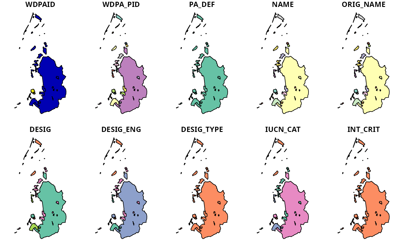
# plot data
plot(lie_raw_data)
#> Warning: plotting the first 10 out of 33 attributes; use max.plot = 33 to plot all
 # fetch data for Liechtenstein using the ISO3 code
lie_raw_data <- wdpa_fetch("LIE", wait = TRUE)
# since data are saved in a temporary directory by default,
# a persistent directory can be specified to avoid having to download the
# same dataset every time the R session is restarted
lie_raw_data <- wdpa_fetch("LIE", wait = TRUE,
download_dir = rappdirs::user_data_dir("wdpar"))
# data for multiple countries can be downloaded separately and combined,
# this is useful to avoid having to download the global dataset
## load packages to easily merge datasets
library(dplyr)
#>
#> Attaching package: ‘dplyr’
#> The following objects are masked from ‘package:stats’:
#>
#> filter, lag
#> The following objects are masked from ‘package:base’:
#>
#> intersect, setdiff, setequal, union
library(tibble)
## define country names to download
country_codes <- c("LIE", "MHL")
## download data for each country
mult_data <- lapply(country_codes, wdpa_fetch, wait = TRUE)
## merge datasets together
mult_dat <- st_as_sf(as_tibble(bind_rows(mult_data)))
## print data
print(mult_dat)
#> Simple feature collection with 63 features and 33 fields
#> Geometry type: GEOMETRY
#> Dimension: XY
#> Bounding box: xmin: 9.475186 ymin: 5.586051 xmax: 171.9985 ymax: 47.26538
#> Geodetic CRS: WGS 84
#> # A tibble: 63 × 34
#> SITE_ID SITE_PID SITE_TYPE NAME_ENG NAME DESIG DESIG_ENG DESIG_TYPE IUCN_CAT
#> <int> <chr> <chr> <chr> <chr> <chr> <chr> <chr> <chr>
#> 1 18107 18107 PA Ruggell… Rugg… Natu… Nature R… National Ia
#> 2 18109 18109 PA Schwabb… Schw… Natu… Nature R… National Ia
#> 3 30747 30747 PA Gamprin… Gamp… Natu… Nature R… National Ia
#> 4 30750 30750 PA Äulehäg Äule… Natu… Nature R… National Ia
#> 5 30752 30752 PA Triesne… Trie… Natu… Nature R… National Ia
#> 6 30753 30753 PA Wisanels Wisa… Natu… Nature R… National Ia
#> 7 30754 30754 PA Birka Birka Natu… Nature R… National Ia
#> 8 30755 30755 PA Schneck… Schn… Natu… Nature R… National Ia
#> 9 30756 30756 PA Au Au Natu… Nature R… National Ia
#> 10 30757 30757 PA Pflanze… Pfla… Gesc… Protecte… National V
#> # ℹ 53 more rows
#> # ℹ 25 more variables: INT_CRIT <chr>, REALM <chr>, REP_M_AREA <dbl>,
#> # GIS_M_AREA <dbl>, REP_AREA <dbl>, GIS_AREA <dbl>, NO_TAKE <chr>,
#> # NO_TK_AREA <dbl>, STATUS <chr>, STATUS_YR <int>, GOV_TYPE <chr>,
#> # GOVSUBTYPE <chr>, OWN_TYPE <chr>, OWNSUBTYPE <chr>, MANG_AUTH <chr>,
#> # MANG_PLAN <chr>, VERIF <chr>, METADATAID <int>, PRNT_ISO3 <chr>,
#> # ISO3 <chr>, SUPP_INFO <chr>, CONS_OBJ <chr>, INLND_WTRS <chr>, …
# }
# fetch data for Liechtenstein using the ISO3 code
lie_raw_data <- wdpa_fetch("LIE", wait = TRUE)
# since data are saved in a temporary directory by default,
# a persistent directory can be specified to avoid having to download the
# same dataset every time the R session is restarted
lie_raw_data <- wdpa_fetch("LIE", wait = TRUE,
download_dir = rappdirs::user_data_dir("wdpar"))
# data for multiple countries can be downloaded separately and combined,
# this is useful to avoid having to download the global dataset
## load packages to easily merge datasets
library(dplyr)
#>
#> Attaching package: ‘dplyr’
#> The following objects are masked from ‘package:stats’:
#>
#> filter, lag
#> The following objects are masked from ‘package:base’:
#>
#> intersect, setdiff, setequal, union
library(tibble)
## define country names to download
country_codes <- c("LIE", "MHL")
## download data for each country
mult_data <- lapply(country_codes, wdpa_fetch, wait = TRUE)
## merge datasets together
mult_dat <- st_as_sf(as_tibble(bind_rows(mult_data)))
## print data
print(mult_dat)
#> Simple feature collection with 63 features and 33 fields
#> Geometry type: GEOMETRY
#> Dimension: XY
#> Bounding box: xmin: 9.475186 ymin: 5.586051 xmax: 171.9985 ymax: 47.26538
#> Geodetic CRS: WGS 84
#> # A tibble: 63 × 34
#> SITE_ID SITE_PID SITE_TYPE NAME_ENG NAME DESIG DESIG_ENG DESIG_TYPE IUCN_CAT
#> <int> <chr> <chr> <chr> <chr> <chr> <chr> <chr> <chr>
#> 1 18107 18107 PA Ruggell… Rugg… Natu… Nature R… National Ia
#> 2 18109 18109 PA Schwabb… Schw… Natu… Nature R… National Ia
#> 3 30747 30747 PA Gamprin… Gamp… Natu… Nature R… National Ia
#> 4 30750 30750 PA Äulehäg Äule… Natu… Nature R… National Ia
#> 5 30752 30752 PA Triesne… Trie… Natu… Nature R… National Ia
#> 6 30753 30753 PA Wisanels Wisa… Natu… Nature R… National Ia
#> 7 30754 30754 PA Birka Birka Natu… Nature R… National Ia
#> 8 30755 30755 PA Schneck… Schn… Natu… Nature R… National Ia
#> 9 30756 30756 PA Au Au Natu… Nature R… National Ia
#> 10 30757 30757 PA Pflanze… Pfla… Gesc… Protecte… National V
#> # ℹ 53 more rows
#> # ℹ 25 more variables: INT_CRIT <chr>, REALM <chr>, REP_M_AREA <dbl>,
#> # GIS_M_AREA <dbl>, REP_AREA <dbl>, GIS_AREA <dbl>, NO_TAKE <chr>,
#> # NO_TK_AREA <dbl>, STATUS <chr>, STATUS_YR <int>, GOV_TYPE <chr>,
#> # GOVSUBTYPE <chr>, OWN_TYPE <chr>, OWNSUBTYPE <chr>, MANG_AUTH <chr>,
#> # MANG_PLAN <chr>, VERIF <chr>, METADATAID <int>, PRNT_ISO3 <chr>,
#> # ISO3 <chr>, SUPP_INFO <chr>, CONS_OBJ <chr>, INLND_WTRS <chr>, …
# }